Ramble On

Wednesday, July 30, 2008

Post 3/Final - Half Dome Summit, Oct 2005

Here’s a final post on the Half Dome Summit Hike…the view near and at the top.


This first one is the view of the south face of the Half Dome from Little Yosemite Valley. When we got to the top of the mountain, we learned that there was a group of rock climbers who were making their way up this side while we were on our hike. They are invisible in this photo.


Also visible in this photo is the cable route. It is just to the left of the big pine tree on the right side of the photo, and shows as a faint line on the side of the Dome massif. As we stopped to take this photo, we could make out people up there, but they don’t show up in this view.


The next photo looks at the view that is behind the hiker as he or she approaches the Half Dome’s shoulder – there is a photo looking towards the Dome in Saturday’s post that shows that view. The mountains in the distance are called Clouds Rest.


Next, a rock climber, practicing the sport on the escarpment at the edge of the Dome. The escarpment is visible from the Valley below, but this climber would be invisible from there. The Valley, as seen from this vantage point, is 4,400 feet below! The time of year that we were there is the high season for climbers, as we later learned.


Final photo, the view of the top of the cable route, as you would see it on your approach back down from the peak. From here it appears to disappear off into nowhere…but the climb down is much easier than the climb up. The woods in the distance are part of the hike - characterized by switchbacks and probably 600-800 feet of elevation change.


Last year Chris and I took a recommendation from Hiking Upward, and hiked a three-state route (VA, WV, and MD) starting from the Loudoun Heights trail near Harper’s Ferry. This hike starts with a rigorous climb and traces part of the AT, walks through the old town and follows the C&O Canal for a short time.


After that hike, despite the fact that at one point hikers are on a bridge over the Potomac that also carries highway traffic, we agreed that this Mid-Atlantic trail was possibly as rigorous at the Half Dome summit. Although the views in Yosemite and the incredible Sierra climate are well worth the trip, there is plenty to do and see here in our area. No shortage of natural beauty or outdoor activities here!

Tuesday, July 29, 2008

The Great Cascade at Yosemite


Yesterday I mentioned the two waterfalls, Nevada and Vernal, at Yosemite, and their proximity on the hiking trail that leads to the Half Dome summit. Here is a photo I found on-line at Wikipedia, taken from Glacier Point, which overlooks this area of the Valley.

This area is also known as the Giant Staircase because of how the elevation change is measured in steps. This is a Spring photo based on the volume of water in the Merced.
There are a number of sites on the webs where folks have posted other views from Glacier Point. I believe it is accessible via automobile, with a short hike to get to the vistas.

Monday, July 28, 2008

Post 2, Half Dome Summit, Oct 2005

While I am on the recent topic of the Half Dome climb in October 2005, thought I would add a couple of additional photos and tell a bit more of the story.

Chris and I decided we would go out and take on this hike as an alternative bachelor party for him, as his wedding approached later that month. We had prepared for the long hike over the course of the year, relying extensively on the Shenandoah Day Hikes book, which supplied us with four training routes in SNP, and Hiking Upward, a blog-style site that provides a pretty exhaustive review of more than 50 hikes in the Northern Virginia area.


So our hikes included Limberlost, Dark Hollow, and Hawksbill Summit, as well as the New River Falls, all in SNP. On one day, in fact, we hike the first three in succession. We also had an early climb of Sugarloaf in Maryland, and did a couple of the Knob hikes from Hiking Upward.
I figure our longest hike, crafted out of these excellent resources, would have been about 8 miles and included 2,000 feet of elevation.

Even though this kind of workout in the heat of August here in Virginia, went a long way to preparing me for the Half Dome climb, I could have used a bit more prep. And next time I will be sure to get it!


Now, more photos…the first two, above, are photos of me at the beginning of the hike – we started out while it was still dark. Folks who’ve visited Yosie will know that because of the depth of the valley, the light takes longer to get there – this photo was actually taken at around 7:30 am, something like two miles into the hike.

Second one is Chris at a stop we made at the top of the Nevada Falls. The trail leads up through the gap behind him, which goes to what is known as Little Yosemite Valley. There is a backpacking campground up there, available only during the Summer. At this point we were about ½ of the way through the outbound portion of the hike, and probably had covered somewhere between 1/3 to ½ of the total elevation change.

Also, there are two photos of the waterfalls that highlight the hike – the Vernal (317 feet) and Nevade (594 feet) Falls. These two falls are within a mile of each other…but it is a steep mile - almost 1,000 feet of elevation change!


There is a fairly rigorous hike called the Mist Trail along the Merced River that takes you up to the Vernal Fall. One part of the trail, which walks along a cliff, is shown in the final photo. During the Ppring melt, these falls are really a show – have to admit I’ve only been to the park in the Fall season.


Sunday, July 27, 2008

Confessions of a tech-watch geek

Out in Page County we have a great benefit with the Appalachian Trail running along the ridge of Shenandoah National Park. It is a great thing to find that here and there in all the day hikes available in the SNP, many of them involve short stretches of the AT. And as one hikes some of the trails, or takes a break at the Tap Room in Skyland, you might run into a through hiker, who’ll share some of their experiences from the trail.

Last week, I picked up a copy of Outdoor magazine to read on the LA-DC flight. The magazine contained an ad for the new Casio Pathfinder watches…I have to admit I am a watch-geek when it comes to these products.

I still have a Casio I bought in Santa Barbara in 1998; it had a little phone number data base (mobile phones weren’t so prevalent yet back then, and their use as an address book wasn’t nearly as mature as it is these days). When I page through my phone numbers there, I find a list of clients I was working with at the time – IRS real estate people, FAA real estate people, and Army real estate people. Fun to remember those projects - I wonder if they still have these phone numbers.

I also have G-Shock watch that I bought after a 2006 trip to LA, I’d always wanted one of those clunky things and the one I chose has an analog and digital display of the time, so I can keep track of the home and local time zones during travel. I don't mind saying that I enjoy the perception of tech-cred this watch advertises.

These new Pathfinder watches bring watch-geekdom to a new level. They’ve added atomic time keeping and solar power to the features…but even better, for outdoor activities, there is an altimeter, a barometer, compass and tidal/moon phase graph available.

I know that my reaction is going to be very consumerist and American here, but I have got to get me one of these. I can see Mary's frown in my mind. But she just doesn't understand that with one of these watches, I can be confident we will never be lost on one of our two - to - four hour day hikes in the SNP. And I can know when to look forward to the new moon so we can stargaze from the brick terrace at the cabin. Etc., etc...sad, eh?

Here’s the ad copy from one of the Casio pages: “Pathfinder watches not only feature authentic outdoor styling, but have distinguished themselves as “genuine tools” for use in the Great Outdoors. Every model is equipped with sensors to help you observe Nature and monitor its changes."

A second area on this page that caught my interest was a “journal “ from an AT through hiker who supposedly used on of the watches on his hike. Thirteen stops are chronologized on this journal:

· Springer Mountain, GA
· Brown Fork Gap, NC
· Icewater Spring Shelter, NC
· James River, VA
· Rusty’s Hard Time Hollow, VA
· Boiling Springs, PA
· Dan’s Pulpit, PA
· Wiley Shelter, NY
· William B. Douglas Shelter, VT
· Tucker Johnson Shelter, VT
· Gatehead Hut, NH
· Moxie Bald, ME
· Kathadin, ME

It’s not unusual to run into through hikers in the Valley during the hiking season, in fact the Page News and Courier had a two page spread on a couple doing the hike recently. While the webpage here is an ad, the posts reminded me of the hardships of this hike…I still have to come to terms with how I am going to tackle it someday. http://pathfinder.casio.com/ .

Saturday, July 26, 2008

Fall Hike Plans and Half Dome Summit Memories

As the summer gets on, I’ve been thinking a little about some Fall hikes. We’re in the preliminary stages of planning but I have been thinking about Duncan Knob over in the GW Forest and then another Old Rag summit…we can do Duncan Knob on a weekend, but Old Rag is best during the week, probably in November. Proximity to these activities was a big part of our decision to buy the cabin.


These thoughts raised some nostalgia…it’s been nearly three years since Chris and I went out and hiked the Half Dome in Yosemite. Here is a hike map and some highlight photos.


First, a view of the mountain from Mirror Lake in the Yosemite Valley. The vantage point for this photo is accessible from most of the lodging and camping sites in the Park; it is a short walk from one of the bus route in the Valley. There is another vantage point that is always crowded with people. Which I find ironic, because it looks like blissful solitude abounds, but most likely the shot is being taken while the photographer is surrounded by 50 or more people! Of course I have a photo or two from there.


Next, a view as we approached the summit, about a half mile away and something like 600 to 1,000 feet left to climb. We did this in October 2005, while the trail was under construction and only open Friday through Sunday. The number of people in this photo is probably only 20 to 30 percent of the people who might be on this hike in the summer while school is out. Click on the photo and you'll be able to make out all the people on the trail - don't forget to nav back!

The third photo is of the famous cables (click on the photo for a better look, and nav back to this page!). This route is open from April to October every year – our hike was the last week in 2005. It is said that this route is unscalable to the average hiker without the cables. There are horror stories about people falling down, but the majority of folks can do this without much trouble. More likely there are traffic jams and the like that make this tough, as opposed to accidents. Not to say, there haven’t been any.


This last photo is Chris and me at the summit. It was a great feeling and a great place to be. While our training hikes were throughout the Shenandoah Valley, we’d not encountered anything quite like this (4,500 feet of elevation change, 17 mile round trip, etc.). As we started to climb the cables, clouds passed over and a wind started up, quickly dropping the temps to the mid-50’s, so we put on the long sleeves for the final ascent. Soon as we were up, the temp got back into the high 60’s and those duds had to come right off.


I think I will post a few more highlight photos of this trip during the next week or so. We lent to cabin to Chris and Jeanene this weekend, so we will have been away three weeks when we get back.

Thursday, July 24, 2008

Gas Price Nostalgia


This one is making the rounds on email lately. It's funny enough I thought I would post.


You might remember this accident that happened 6 years ago this past March.This Southwest Airlines flight from Las Vegas overshot the runway at Burbank.The plane smashed past the airport fence, careened across the street and ended up with a collapsed landing gear, right next to a gas station. But that's not the most amazing part...


Road Trip: LA Final - Manhattan Beach


During the trip, Bill G and I stayed at the Marriott in Manhattan Beach. This westward orientation during the trip was something new for me, as whenever I've been out before, I usually end up in the mid-Wilshire area, downtown, and in the case of one of my past Booz Allen projects, Arcadia.

After the USC events of Thursday and Friday (and the after event we enjoyed with Ryan on Friday night on Abbot Kinney in Venice) we did a little sightseeing down at the beach. We found a great beachside restaurant for breaksfast, Uncle Bill's Pancake House, and then took a stroll down to the pier.


Almost as far as the eye could see, from this vantage point, there were volleyball nets set up for league play. It seemed like hundreds of them. In the DC area there are leagues for volleyball, with nets set up along the National Mall, but nothing like this, with sponsorships, advertising, and the like.


Plus they've got two things we don't - the weather, and the beach.

As a wrap - a good trip. Back to the cabin in the next post.

Wednesday, July 23, 2008

Road Trip: LA - Events at USC


The whole purpose behind the trip to LA was to attend a couple of events at USC, where I went to business school. The graduation of the most recent MBA class – IBEAR 30 (or XXX, out of respect for one of LA’s most prominent industries!) – and a reunion to celebrate the program’s 30th anniversary were the two focuses of this part of the trip.

The IBEAR program is an internationally-focused accelerated MBA for executives, completed with one-year in residence. Among the things you come away with, at least for my part, is a life-long affiliation with the university (you become a diehard Trojan football fan too).


Bill and I attended the graduation dinner on Thursday night, where among the festivities was an appearance of the Trojan Marching Band. These guys are among the best in the nation, and it is a good bet that if you see a marching band in the movies, it will have a number of these students in it – the band in the parade in the movie Animal House was the USC band, for example.


On Friday, there was a full day of networking and conferences on the future of the program – a retrospective and then look ahead, complemented by a lecture by leadership guru Warren Bennis (http://en.wikipedia.org/wiki/Warren_Bennis) . The program also included some prominent IBEAR MBA alums, including the CEO of the Hanjin Group, parent of Korean Air and Omni Hotels. Really good insight and food for thought.


In the afternoon, a party ensued. There were a lot of my classmates in attendance (11 years later!) and a highlight of the evening was performance by The Retreads (http://www.theretreads.net/news.html) , who came in from Boise. One of the band members is an alum; as a matter of fact he worked at Capital One in Richmond for some time and was here for the USC-Va Tech game in 2004. A good time was had by all…

Tuesday, July 22, 2008

Road Trip: LA Continued - Long Beach and San Pedro


Before we get to the actual business purpose of the trip - the events at USC, here is another entry on sightseeing in the LA area. Among the people I try to link up with whenever I am on the west coast is a friend of mine from Jacobs - Ryan. We worked together from 1999 to 2001 or so, and stayed in touch after that, until he eventually moved to LA for the USC MBA program.


Ryan is at Toyota now, and lives in San Pedro on top of the hill. Here are two photos of the Port of LA and surrounding San Pedro (or "the 'dro" as he calls it) taken from the deck of his house.


After some refreshements, we took a short walk to the Korean Freedom Bell park that is near Ryan's house. This park is featured in a scene in the movie "The Usual Suspects" - another fun thing about visiting the area. Here are Bill and I near the pogoda. I realized when I uploaded these I don't have one of Ryan or Marlin, his Boston Terrier, who took the walk with us.


Closing out this entry with a couple of photos from the Long Beach Airport, taken during our departure. This first one is of the tower, taken from the observation deck that overlooks the airfield. Besides the deco-era design, of note is a series of exhibits on aviation history that took place here - there is a long tradition that centers on the World War II effort. If you take Jet Blue to Long Beach it is definitely worthwhile to take a little longer to check it out.

Also, this last photo from the observation platform. Our plane was the one on the right. I wanted to take the photo because in the background was an Air Force base - and if you look closely at the plane above the cockpit of our Jet Blue aircraft, you'll see it is a B1-B...despite the quality of the phone cam photo, I was excited because this is the closest I've ever come to one of these.

Monday, July 21, 2008

Another update on the nesting hawks

A diversion from the Road Trip Los Angeles posts...Mary tells me that the young hawks are still hanging around, flying from tree to tree. After reading additional background on Cooper’s and Sharp-shinned Hawks, I decided to send a message to the Feeder Watch group at Cornell University.

Below I am excerpting two messages from Anne Marie of that group. Plenty of helpful information here, detailing the difficulty of identifying the two species. I’m left wondering which kind we had, most behaviors match “sharpies” but the call sounds like Cooper’s…you can follow the link in here post below and hear samples of their calls.

“Both species prefer to nest in conifers, but I believe that Cooper's Hawks tend to favor Red Pines at least in our area. I am not aware of significant differences between the two species in the location of nests within a tree. To my knowledge the breeding cycle is pretty similar for the two species as well, although Cooper's Hawks may start a bit earlier. There are definitely differences in their flight pattern and shape, but I have found the differences difficult to see except during migration when long flights can be observed. I am glad you had a chance to listen to the calls. Those can be very helpful.

These species are very difficult to tell apart. I have seen ornithologists look at the same photo and disagree about identification. (note the post with photos is http://hawksbillcabin.blogspot.com/2008/07/nesting-hawks-encore-with-photos.html)

So if you never figure it out, don't feel bad. It is very likely that the hawks will return to the same area to nest again next year, and in the case of Cooper's Hawks, they may even use the same nest. So if you will have another chance to identify your hawks next spring.”

…and…

“…I can't tell from the photos which hawk you have. You can find tips for telling the two species apart here:http://www.birds.cornell.edu/pfw/AboutBirdsandFeeding/accipiterIDtable.htm

From the pages linked at the bottom of that page, you can find recordings to listen to, which might help. With the juvenile birds, the best field mark is the thickness of the vertical streaking on the breast. With the adults, the best field mark is whether or not the feathers on the back of the neck are light or dark. The two species overlap in size, and given how difficult it is to judge size, it is not usually a reliable field mark.”

Road Trip: Los Angeles

Just back this morning from a long weekend trip to Los Angeles, where I enjoyed catching up with friends and a couple of reunion events at the University of Southern California, where I went to grad school. I have four posts planned on the trip.


We have a number of activities going on with the cabin as well. Mary was out for the weekend, meeting with Uncle D, painting, and typical activities. She tells me the hawks have not left yet and are still vigorously flying around the property. I have an email from Cornell University on identifying Coopers Hawks from Sharp-shinned Hawks - I have been struggling with this and the email has left me more confused.


On to the LA visit...


I travelled with Bill - a neighbor here in Alexandria who also attended the USC IBEAR MBA program, although he was there a few years before me. We flew on Jet Blue, where with only two weeks notice we still got round trip fares of $350 (and exit rows seats outbound!). This first photo is of the Long Beach airport terminal. This is the second time I have flown out on Jet Blue and each time I see this terminal it reminds me of the National terminal here in DC.


After driving up the 405 to our hotel in Manhattan Beach we stepped out for lunch. A short drive down to the beach and we found this place, The Kettle, a 24-hour diner, and we grabbed a bite. While our schedule was hectic on Friday, we were back in the beach neighborhood for breakfast on Saturday and Sunday.


On the flight out, I read Wired magazine and found some information about an exhibition on John Lautner, an LA practicing architect with many contemporary residences to his credit. The show was at the Hammer Museum up in Westwood (in fact, it is a UCLA-run institution), so we took a quick drive up to check out the show.

Here's a bio excerpt from the exhibition catalog: John Lautner (1911-94), one of the most important and influential architects of the twentieth century, had a remarkable career spanning nearly six decades. Residing and working in Los Angeles during much of that time, his designs are known for their radical innovation with specific attention to materiality, space and a consciousness of the natural environment.

The homes offer an interesting perspective of contemporary LA in the 50's, 60's and 70's. They've been featured in a number of movies. Several of the homes are featured in the exhibit: http://www.hammer.ucla.edu/exhibitions/139/works_1.htm ...there is more at the Lautner foundation site:
http://www.johnlautner.org/wp/

And one of the homes was in one of my favorite LA movies (I have a growing collection of LA-themed movies, currently numbering 12) - The Big Lebowski. Here's a blog post on the exhibition that ties one of the houses in - in the film, it's where Jackie Treehorn resides - and although the story sets the house in Malibu, it's actually on a ridge overlooking the valley.
http://la.metblogs.com/2008/07/19/stay-out-of-the-sheatsgoldstein-residence-lebowski/

Wednesday, July 16, 2008

Pool Liner and Equipment Installation


Installation has begun on the pool rehab. Our first tip was this big trailer parked in the drive when we arrived on Friday night.

New pump, filter, return system, light and liner are all part of this effort. The surrounding brick terrace will be removed and replaced with concrete, following up on some of the other work begun this summer.
Here are a couple of progress photos of the return installations. Uncle D tells us they should have this completed by the end of the month. So we could have as much as six weeks to enjoy the pool - this was such a great announcement that we celebrated by going to the dollar store and buying some "noodles" and towels.

This is the third of three major projects nearing completion for the year. We are beginning to plan the efforts for the Fall.

Tuesday, July 15, 2008

Nesting Hawks Encore - with Photos


For several months now we've had a pair of Sharpshinned Hawks nesting in the big pine tree in the front yard. There are four or five previous posts on the topic, which were summarized in last week's entry "Nesting Hawks Finale" -link below. I thought the four nestlings would have flown off by now, but to our surprise, three of them were still around last weekend. Mary and I were treated to a show of flying lessons, as the young birds flew from tree to tree and could be spotted over in the hollow, down at the stream, and in the tops of the trees in the back yard.


After the Sunday rains, I was able to catch a few photos of them at last, using the digital camera and zoom. The quality leaves something to be desired, but I wanted something to document the experience, so they are satisfactory. The first is of one of the nestlings sitting alone on a branch, where it had been preening and drying itself after the rain. The second is of the other pair of nestlings, who for a moment sat together on a branch in another tree.


For a recap of all entries, check the previous entry on the hawks at http://hawksbillcabin.blogspot.com/2008/07/nesting-hawks-finale.html .

Monday, July 14, 2008

Hoppin' Toads

There is some unknown attraction our empty swimming pool holds for toads. Last year, there were several times I was exploring down there where I found juvenile amphibians hopping around - of course, once they're in, they can never get out...


So on Saturday, while we were waiting for the electrician, we enjoyed a cup of coffee on the brick terrace. I was concentrating on the hawks - apparently they hadn't left yet (and I hope to be able to post photos, but not from the phone cam), as I guessed they might last week; meanwhile, Mary was staring into the pool (note, later this week we will have a post on pool progress). "What is that, a toad?" she asked.


I told her, "Yeah, toads get in there all the time. I rescued a few last year."


"I'm going to check it out," she said.


Here is an action photo of Mary chasing the toad around the pool, followed by a photo of the first rescuee. Here also, it is worth noting the protective gear that she keeps around for such endeavors, these prophylactic gloves in particular. No warts for Mary!*


So after the first toad was freed, she came back up and had a sip from her cup. "Is that another one?" she soon asked.


"Plenty of toads around, Mary, so it certainly could be."


"I'm going back in to check it out."


And so, on Saturday she rescued two toads. After the rains on Sunday, I saw a couple more down there, different ones than the two she helped out. It is hard to figure out how they make their way up to the terrace and deck by the pool, and then how do they survive the fall into it? The pool is four feet deep at its shallowest.


* We know this is an old wives' tale. Mary is just sqeamish.

Sunday, July 13, 2008

The Girls


Here is a photo of Sofie and Gracie (Gracie's the border collie) taken while we were getting ready to leave the cabin on Sunday. It was after a rain, which seems to be happening every Sunday lately, and I used my new AT&T Razr Cam. Seems to have better quality than the old one - no surprise, that one was three years old. Also, we get signal at the cabin now - up to three bars in the yard (nothing doing in the stone part of the house though!) ...

Thursday, July 10, 2008

Nesting Hawks Finale

Last weekend, we had the opportunity to enjoy what may be the last few observations of the hawks that have been nesting in the big pine tree at the Hawksbill Cabin. Earlier we identified them as Sharpshinned Hawks, a breed that has an extensive range across the Continental US, from their nesting habit in dominant conifers, and from their size and other behaviors.

Since April or so a pair was hanging out around our property and coming and going to the big tree. Eventually the nest was built and there was a clutch of eggs. Then we started to hear the nestlings, and there was a lot of parental activity as the care and feeding began. Finally last weekend, the nestlings were big enough to see on their own – and we learned there are four of them.

Unfortunately, because of their nesting site, about 70 feet up the tree, I have never been able to get a good phone cam photo of them. And now they are nearly adults, so I expect that by the time we are out this weekend, they will have left the nest. On a couple of occasions last weekend, two of the youngsters flew out of the tree into neighboring ones 30 to 50 feet away – definitely trying out their wings – and always returning to the nest at night or on arrival of one of the parents.

As we move on into the summer and the hawks depart, it’s been great having them around and learning so much about them. Here is a recap of the past posts on them:

http://hawksbillcabin.blogspot.com/2008/06/of-frogs-hawks-hummingbirds-and-deer.html
http://hawksbillcabin.blogspot.com/2008/06/then-there-were-three-nesting-hawks.html
http://hawksbillcabin.blogspot.com/2008/05/nesting-hawks.html

Tuesday, July 8, 2008

Rapidan Camp Hike - Wrap


Continuing with our July 5 hike... After passing Big Rock Falls, it is only a short distance into Rapidan Camp. This historical site sits in a relatively flat area at the confluence of the Laurel and Mills Prongs, and is also where the Rapidan River starts.


The Hoovers chose this site based on three criteria: 1) the retreat needed to be within 100 miles of Washington, DC; 2) the minimum altitude was to be above 2,500 feet to eliminate mosquitoes; and 3) a trout stream had to be immediately accessible. They bought the land with their own money and paid for many of the improvements, augmented by the Marines who built some of the improvements as training.


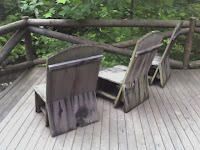
We walked down to the “Brown House,” or Presidential Cabin, where we sat in these chairs, overlooking the rustic bridge, and had some sandwiches. The bridge is rebuilt, but there are pictures of Hoover posing on it. Also, the chairs are of the original design, and the publications say that Hoover often sat out on this deck enjoying the stream.

One other note about this spot, Roosevelt visited the camp as the Hoovers had dedicated it to successor Presidents. The camp was difficult for Roosevelt to get to, and get around in. But it is said that he sat in this spot to consider whether or not to use the site for his own retreats; he preferred Georgia, New York, and Maryland for this purpose and never returned.


The only President after Hoover to use the cabin was Jimmy Carter, in fact, who was here in 1979.


Over the four years of Hoover’s term, he spent most summer weekends here.


Notable visitors included the Prime Minister of England, who was on a state visit to discuss naval arms limitations. This cabin is known as the Prime Minister Cabin and includes excellent interpretive displays.


Also, as the Depression advanced, Hoover was very involved in arranging financing for bank rescues during his stays here.


Finally, the large outdoor fireplace here and in the first photo above was used for photographs and for gatherings in the evening. As luck would have it, my phone cam shot illustrates how the design of this fireplace was repeated in the cabins and other buildings. The camp was used during three seasons eventually, but it immediately fell into disuse at the end of the Hoover administration.


We bought a little history book at the Big Meadow ranger store and I read it Sunday. The camp had as many as 22 structures for guests at one time, but only three remain. There was an entire separate camp for the Marines who stayed in the Park while the Hoovers were there. Also, as they got to know some of the mountain people in the area, the Hoovers built a schoolhouse to educate them.


The property was eventually used by the Boy Scouts in the 1950’s, but without a swimming pool, it wasn’t as well used as some of the other properties they had access to, and the facility was eventually turned over to the National Park Service for management. Today there is a volunteer who resides on-site in “The Creel,” one of the original buildings.


There is a good review of the hike on Hiking Upward (http://www.hikingupward.com/ - search for Camp Hoover) and of course additional historical information at Wikipedia.

Hike Recap - July 5, Rapidan Camp in SNP


On July 5, we realized that we hadn’t been on a hike for a few weeks, so we consulted our easy day hikes book for a referral. We’ve done a number of the hikes there already, but there are plenty to go…and for reference, while it is entitled easy day hikes, some are rigorous – the title refers to the time frame of the hikes, meaning these do not require an overnight backpacking trek.


We chose the Rapidan Camp hike as our destination for the day. It has an interesting historical objective among its features: the hike descends along a stream to the summer White House used by Herbert Hoover. Tomorrow’s post will discuss this objective.


We parked at Milam Gap, just a few miles south of Big Meadows in the SNP, and found the trailhead across Skyline Drive. Some readers may not be familiar with hiking in the SNP – frequently, and especially with these easy day hikes – the trip either immediately descends down the mountains, with the return consisting of a climb back up (sometimes it’s steep as in Dark Hollow Falls); or you begin with a climb and the return is downhill (as with Hawksbill Summit). It isn’t always this way, but it frequently is.


As we got underway, among the first sites was this fern glade. We have been talking about naturalizing the cabin’s front lawn…when I think of that, the picture that comes to mind is like this one. Although I may be wrong, my recollection is that this sort of environment is only encountered on the east side slopes of the Park, probably has something to do with the leeward direction and the rainfall in the woods.


A feature of this hike is the fact that it follows Laurel Prong – a small stream that is highlighted as a trout fishing destination (catch and release only!). Laurel Prong joins Mill Prong (interesting they are prongs here, not forks) and at the confluence becomes the Rapidan River – and that is where the little camp was sited for Hoover.


Here are a couple of the stream crossings on the hike – the route we chose featured three crossings such as these.

Finally, at the bottom of the route, and 500 yards or so from the camp, there is Big Rock Falls, shown in the photo at the top of this entry. This is a small waterfall compared to others nearby in this section of the Park, but it is among the most scenic.

Tomorrow’s post will go into some detail about the camp itself. It was a very interesting destination for us. And this is a hike we will take again – there is opportunity for extending it over some varied scenery and crossing other streams in a longer circuit hike, as opposed to the out-and-back we did.