Ramble On

Monday, October 31, 2011

October Nor'easter

All week long there was that looming forecast of a winter storm coming, predicted to hit the mid-Atlantic region by Halloween weekend.  And so it did.

This was an early snow, mixed with sleet - it was very wet, and quickly adherred to the remaining leaves on the trees.  As Tessie and I were hanging around in the cabin Saturday morning, we were constantly interrupted by the burst and crack of trees branches coming down in the wood lot under the weight of the snow.

Tessie and I took a little walk to check things out.  She was very excited to be out in the snow, so much so it distracted her from her business - we went out no less than three times before we had "results."  

All the shrubs were weighed down from the snow.  They survived the "Snowpocalypse" in 2010, though, so hopefully there isn't much permanent damage or loss.  Also, we found that you can finally see Beaver Run again with the leaves down.

Weather like this sets up a very beautiful scene, despite the cold and inconvenience - our power went off at 9:00 am; I didn't expect it to be restored until at least Sunday.  Fortunately, the gas heat works without electricity, so I turned it up a little higher than usual and the two of us bailed for Alexandria on Saturday afternoon.

We made a quick stop in town at Hawksbill Bicycles, where Chris and Rob were setting up for the Chambers downtown Trick or Treat event. 

Luray was abuzz with all the festivities, between Darkwood Manor just behind there, and a metal music fest that was also scheduled for the evening.  There's always a lot going on, maybe surprisingly so, for such a small town!

Friday, October 28, 2011

Door Chore

During my furlough, I had resolved to take care of a few small maintenance projects around Hawksbill Cabin - as if, because I'm so handy, all that I really needed was the time - one that I am really good at though, is painting.  So I've begun to get some much needed touch ups done.

We have this fabulous door at the entry to HC - it has an elaborate, heavy duty hinge assembly on dutch panels.  An additional layer of wood planks was installed on the interior part, so it's double thick.  No bear is getting in while we are away, and I think the door would survive a tree falling on it...knock on wood that that doesn't happen.

The door faces south, so it gets the sun year round, and lately, I've begun to notice that the paint was fading.  Worse yet, apparently, somewhere along the way, someone had used spray paint for touch ups, and now the traces of two finishes were beginning to show, a glossy finish from the spray paint and something more of a matte on the undercoat. 

Off to Lowes for a gallon of exterior latex in color Merlot. This is the same color we've used on the hand rail that surrounds the brick terrace.  I've got a picture here of Tessie supervising me painting those.

There are also some color panels on the addition (I hope to get these taken care of during the fall). Although the front door needed painting, these are the real motivator for the project...the frames for these was painted in an oil-based black enamel, which is peeling.  That is what I am really trying to get to, but I thought I would start with the red paint first, and do the detail after.

Finally, there is a mistake that I made a few years ago, that needed to be corrected, and now finally has been.  I painted the doors on the barn with an idea of tying the outbuilding thematically to the house.  Unfortunately, the paint I chose was in the color "terra cotta"...which gave a distinctly Harley Davidson appearance - there used to be a Harley in there, but not any more these days.  Here's a link to a blog post back when I painted them the first time.  http://hawksbillcabin.blogspot.com/2008/06/catching-up-on-few-small-projects.html

All good now though.  Those doors are the color of a fine wine!

Thursday, October 27, 2011

Meet the Yum Yums

Well, I stand corrected.  In a recent post, I referred to these guys as:

  • Ham,
  • Bacon,
  • Pork Chop, and
  • Chorizo
But I have been reminded that those aren't their real names.  They are the Yum Yums.

Last week I stopped by for a check-in at David's suggestion.  Our red oak acorn crop back in Alexandria has been so bodacious that I brought along a couple of pounds of them in a sack.

See, David told me about how the pigs behaved when they got the white oak acorns a few weeks ago - I had collected them from the yard in Stanley.

Pigs earn their reputation from how they are when it comes to eating.  They are aggressive.  They are sloppy.  They are loud.

But give them an acorn, and they recognize it as a delicacy to be savored.  They sniff around to find it on the ground, pick it up gently in the mouth, purse their lips and gently chew with the teeth in the front of their mouth.  The facial expression is almost a pucker. 

It was every bit as entertaining as he promised it would be.

So maybe the pigs are growing on me.  Okay, we can call them the Yum Yums.

But come February, they are Ham, Bacon, Pork Chop, and Chorizo, as far as I am concerned.

Wednesday, October 26, 2011

The Whip It Meme


Some pretty good Facebook posts of late playing off of the old Devo song.


And here's a link if you need a reminder.

http://youtu.be/IIEVqFB4WUo

Tuesday, October 25, 2011

Page County Crop Relief

Here's a quick video story from WHSV on the feed corn crop in Page County this year. Yields have been very low and potentially qualify our farmers for federal and state disaster relief support.

Page County Crop Relief

One of our Page County Grown farmers, Jared Burner, of Skyline Premium Meats, is interviewed in the piece.

Monday, October 24, 2011

National Geographic on America's Most Popular National Parks

Hot off of a series of posts on Death Valley, I found a series of articles on the National Geographic site today that profile America’s most popular national parks. These include four of the parks that I have posted on here on Hawksbill Cabin since 2009:


  • Shenandoah National Park
  • Yosemite National Park
  • Grand Canyon National Park
  • Death Valley National Park
Links are below, and if you want to read my posts on my visits, just click on one of the labels at the end of the post!

http://travel.nationalgeographic.com/travel/national-parks/shenandoah-national-park/

http://travel.nationalgeographic.com/travel/national-parks/yosemite-national-park/

http://travel.nationalgeographic.com/travel/national-parks/grand-canyon-national-park/

http://travel.nationalgeographic.com/travel/national-parks/death-valley-national-park/

Leaving Las Vegas

Well, I surprised myself at the number of posts that I was able to pull together about my recent trip to Las Vegas and the side trip to Death Valley.  But all good things must end, and today will be the last post on that topic. By the way, press play on the video above while you read this post, if you'd like some ambience.
These days, and dating back to the early '90's, it's my preference to get an aisle seat on a plane. I'll go to great lengths for that position; mind you, it doesn't offset legroom, but the liberty for just one of my shoulders in the confined space of a flight is worth it. But I put aside that objective for part of the return home from Vegas - the relatively short flight from Las Vegas to Denver - and took the window seat I was assigned. That decision turned out to offer something of a treat.

My view was to the northwest of our flight path, and since we were flying in the late afternoon the sun's rays were not so bright in the cabin. I opened the shade periodically to check progress - I guess I snapped an iPhone photo every 15 to 20 minutes - they are shown here in order. The first is of part of Lake Mead, just outside of Vegas, then they track Nevada and Utah, ending with the snowcapped 14-er in Colorado.


(Note - the blogspot photo interface is giving me fits today. Sorry about the disjointed text layout!)

In particular, as I was flying over Utah, I realized that I was seeing landscapes I drove through once, down I-15 from the Rockies to the Los Angeles basin.  It was amazing, the sense of recognition I had for the views and geology.

On that trip, I had stayed overnight at a Motel 6 in Green River, Utah, with the plan to drive all the way in to Los Angeles the next day. I had car trouble in the southwest corner of that state - after six years of weekends only use the radiator coolant in my Oldsmobile had calcified, and the car was not up to the heat of desert driving. After consulting with AAA (and giving Mary a healthy scare back in DC), they referred me to a 24-hour service station on the Strip in Las Vegas, so for the rest of that Sunday afternoon I limped into the Bright Lights City, driving until the red light came on and then pulling over until it went off.

I got a room in the Motel Six just off the Strip, as it happens only a block away from where I stayed this time.  The service station replaced my radiator overnight (I spent most of the day in the MGM Grand sports bookwatching the ponies); my car was ready by 11am, and I was on the road at noon.  The charge was around $400, very reasonable for what they had to do and for my my circumstances.  They even called Mary a week later to check in and make sure I had gotten where I was going.

By the way, that service station is long gone now, it stood approximately where the Bellagio fountains are now.  But I do remember that experience as among the best adventures I've had, not to mention one of the best customer service experiences I've ever witnessed.

A few years later as I was visiting my grandparents, I had occasion to remember all this when I saw the postcard I had sent them from Green River, Utah on their refridgerator. Grandma said that when they first retired, about 15 years earlier, they had also stopped for a while in Green River - they were car camping though.  That campground was only two blocks from the Motel 6, so it's very likely we saw the same things.

Well, with the photo of the 14-er coming up here, I'm reaching the end of my tale.  I had a great trip to Las Vegas and out west.  If you've never been, it's well worth it. 

Friday, October 21, 2011

Death Valley: Badwater Salt Flats

Visiting here, the baby boomer of my generation feels some vague connection to that old television show Death Valley Days, and the Borax commercials with the twenty mule teams – all of them part of the history of the place, but it is the glowing white stretch of old sea bed, the Badwater Salt Flats, that first comes to mind when I think of when I think of Death Valley.


I arrived here and realized that I had caught up with the tour buses I’d seen earlier over at Zebriskie Point. I recognized one group as Germans, both from the language and because of the naturalist behaviors they immediately fell into once they got out into the salt flat proper – wearing shorts and sandals with wool socks, the men immediately took their shirts off for their walks.

After leaving the parking lot, there is a boardwalk to start the visit. This part of the area needs that protection – there was standing water in the pools, clearly building those little salt formations I’d seen earlier at Devil’s Golf Course.

After getting my picture taken for the Tech-watch Geek post I made last Friday, I decided to walk on out into the desert on the trail surface. However it was done, there is a salt layer that is a couple of inches thick that is smoothed out from the traffic – either the footsteps of thousands of tourists or some kind of construction vehicle had prepared the surface for hiking. There was residual moisture on the surface, making a sort of greasy solution that left footprints, belying what appears to be a glassy smooth area from a distance.

Back to the German tourists for a moment: the salt flats are very much like a snow-covered ski slope, with all the glare. Fortunately the trek out is only a mile each way, maybe less, and I’m sure the bus kept a tight schedule, so sunburn was minimized, even with shirts doffed. Considering this, there was another point of amusement for me with the Germans encountering this environment – so much curiosity and exploration – one fellow knelt on the boardwalk to reach down into the salt water, and brought his hand back to his mouth for a taste!

This is an area where the drama of the extremes is truly evident. As I mentioned in the earlier post, this is the lowest elevation on the continent of North America, officially 280 feet or so below sea level. The sheer cliffs that rise from just beyond the parking lot reach to more than 5,700 feet; across the valley, they reach 11,000 feet, and they are still rising from geologic forces.

I was in the park on a fall day. I’m reading in my guidebook that during the summer, when air temperatures exceed 100 degrees, the ground temperature – those salt flats underfoot – can exceed 180 degrees. And those Germans were wearing wool socks!

The visit to Badwater was my final stop in the valley, as I needed to begin heading back to Las Vegas to return the car. I guess I walked four miles or so all totaled, but the elevation changes were negligible and I’d kept hydrated, so I didn’t feel tired. Quite stimulated by the new environment, one I’d never seen before. There’s quite a list of sights I didn’t make it to – perhaps next time I’m in Vegas.

Thursday, October 20, 2011

Death Valley: Natural Bridge and Devil’s Golf Course

These were my next two stops during my drive through Death Valley. There is a hike in the Best Easy Day Hikes book for the Natural Bridge stop; for Devil’s Golf Course, it’s simply a two mile drive out into the Salt Flats where you can look across a landscape like no other I’ve ever seen: desolate and treacherous, totally uninviting.


The book describes the hike to Natural Bridge as a walk through a gently sloped canyon with a climb totaling 520 feet. It’s listed as a two mile hike round trip, but I probably only did half of that, and I certainly didn’t partake of the whole climb. The bridge appears early in the canyon; there are quite a few other geologic features here to explore, culminating in a “dryfall,” which marks an area that turns into a waterfall when it rains enough.

The kiosk at the trailhead explains all of the geologic phenomena that hikers encounter here, including different kinds of faults and arches, and mud drips. The view over the salt flats from the parking lot is awesome and intimidating at the same time…I found that I was amazed enough at the view and experience that I was more exuberant than some of the other tourists could take. I wonder whether they would enjoy a hike with me on my home turf in Shenandoah National Park.

These mud drips were particularly interesting. Bigger flash floods have done the bulk of the work carving out the canyon and the natural bridge, but the mud drips emphasize the ceaseless erosion that is happening here. When there is enough rain above, it drains from the higher surfaces into the canyon, leaving tracks of sediment on the walls as the water evaporates to a trickle – and frequently doesn’t even reach the canyon floor. I took a close look and touched one of them – the mud tracings are like wax, shiny and translucent – and then stepping back, you see that the whole canyon wall is etched with them. Beautiful.

Getting back to the car, I took a break for some refreshment and then headed to Devil’s Golf Course. That involves a drive along a gravel road out to a cul de sac, where there are some interpretive signs about the landscape, which begins abruptly off the shoulders of the road. Thankfully, few people walk out into the area here, so the landscape is close enough to natural for all to enjoy.

The salt flats periodically fill with water after heavier rains, so the runoff pools in basins and then soaks into an ancient lake bed. It becomes a solution with the residual mineral salts, carrying them to the surface when the water evaporates. There the minerals adhere to sand and rocks, crystallize, and then build rough, irregular formations.

It would be difficult to walk very far here because the structures are fragile and would quickly take their toll on ankles and knees. A fall would leave you bruised and bleeding, stinging from the salt that would grind into the scrape wounds.

Yet, wildlife flourishes here, with specially adapted species (1,000 of them, according to the NPS handout) living here and elsewhere. I figured that was another good reason not to venture far out into this area. Taking a look from the safety of that little cul de sac in the desert was enough for me!

Wednesday, October 19, 2011

Death Valley's Golden Canyon Interpretive Trail

As advertised in the Best Easy Day Hikes book (Amazon link at the end of the post) the route for this hike follows a sand and rocky wash trail through a canyon for about a mile, and covers about 250 feet of elevation change. There is an option for a longer hike of about 6.5 miles, with 960 feet of elevation change, which goes back into the Zabriskie Point area. I chose the short route, since I knew I had a couple of additional stops to make while I was visiting Death Valley.


There is a story about the rocky wash. Apparently there was a road up into this canyon at one point, but a sustained rain in the ‘70’s dropped more than two inches of precip here, and the old road washed out. Now the route is restricted to ped’s, but it is a very interesting route.

A key point of interest is what’s happening here, in a canyon that is estimated to be only 3 million or so years old. That’s young by geologic standards (during my trip to the Grand Canyon, I recall that the exposed rocks near the river are billions of years old – half the age of the earth). You can see the rock layers, also called the Furnace Creek Formation, that have been carved out by wind and water, and then traces of seismic activity, so it’s almost like the earth is changing right in front of you.

I was particular struck by the one at the beginning of the post, it is a peak of bleached out sandstone.  All along the face of it climbing out of the canyon are chimney like gulleys that have been carved into its face. There were several of them, the photo I have is the one that showed the contrasts best – the images didn’t capture the depth of these very well due to the bright sunlight.

I spent an hour up in the canyon, walking probably about a mile. Ahead there was a rock formation called the Red Cathedral, which can just be seen in one of the photos. It was right about this point that I started noticing that the polarization in my sunglasses was highlighting colors I hadn’t noticed when I took my shades off – particularly greens and violets, so I stopped for a few to examine these features more closely.

The angle of these rocks, tilting upwards to the west, is a testament to the ongoing changes. Apparently, the western mountains continue to be thrust upwards, while the valley itself continues to gradually sink.

Coming to terms with the scale of the changes and the relatively short timeframes of the events brought home the fact that human activity can have a profound impact on the planet and our environment. That’s nothing that hasn’t been said before, I know, but for me, it only served to reinforce thoughts about my own responsibilities with respect to the environment.

Here’s a link to the Best Easy Day Hikes book:

Tuesday, October 18, 2011

Death Valley: This is a Dangerous Place

“1904: Gold—found just east of what is now the park—sparks the last great American gold rush. The gold rush draws 10,000 people, three railroads, and a masonry, three-story bank to the district of Rhyolite.”

– From the NPS Death Valley Brochure

The photo here is of the Ashford Mill ruin, which is in the south part of the road-accessible portion of the park. Rhyolite is just out of the park to the northeast, it's a little town surrounded by several ghost towns. The sign accompanying this ruin explained that it was built as a mill, where ore containing gold was taken to be processed during these gold rushes (there were a couple, and Death Valley even has a connection to the 1849 California gold rush).

Seeing it standing there in this condition was a final reminder of how harsh this environment is. I stood there for a moment contemplating how 10,000 people could live in this heat, without ready access to potable water or food. Yet before them, essentially since the Ice Age, there has been a population of Native Americans living in this area…granted, it hasn’t always been this way – more on that when I post about Badwater.

When I bought the little Best Easy Day Hikes book at the start of my visit, I took a few minutes to leaf through as I chose my itinerary. There are three pages full of warnings in a section entitled “Play it Safe.”

Seriously, among the dangers in this park are:

• Dehydration
• Weather
• Hypothermia/Hyperthermia
• Vegetation
• Flash Floods
• Rattlesnakes, Scorpion and Tarantulas
• Mine Hazards
• Unstable Rocky Slopes

I thumbed through this section in the parking lot at Zebriskie Point. Even though I’d stopped at Target back in Las Vegas to prepare and had two liters of water handy, these warnings were enough to convince me to go to the camp store at the visitor center and pick up another gallon of water (which I gave, unopened, to the attendant when I returned the car – two liters was enough).

As far as animals and wildlife go, I did see a gecko. And there was the periodic buzzing of some insect circling me as a blood meal prospect.

But once I got back in the car after visiting the Ashford Mill ruin, I reflected on a pretty fulfilling experience. One that I survived.

Tomorrow I’ll start the posts about the day hikes.


Easy Day Hikes book link (Amazon): 

Monday, October 17, 2011

Death Valley Intro

As a person who was born and raised on the east coast, and who has lived there pretty much all of my life, with the exception of a couple of years of school in Monterey and Los Angeles – and my enlistment, which was spent in Berlin, I’ve always been fascinated by North America’s western land and seascapes. So with found time on my hands in Las Vegas last week, I sought out a suitable daytrip.

Mind you, this time I wasn’t looking for anything as dramatic as the helicopter ride into the Grand Canyon, which I did in 2009 – there are posts under the “Las Vegas” label below. But I did hope to check the box on yet another national park. Preliminary research told me that Death Valley was a two hour drive away, so I rented a car (on Priceline) and took the daytrip up.

I’d seen all the pictures of the desert emptiness. Most of the photos I had seen were focused on the Badwater salt flats, definitely a highlight as the lowest point in North America. But I wasn’t prepared for so much else that you can see in this park.

The NPS brochure that you receive after paying your visitor fees summarizes the contrasts that you can experience here:

“Great extremes haunt this hottest, driest, lowest national park. Extremes in temperature and elevation create scenic vistas and ecological niches that host startling biological diversity. This desert supports nearly 1,000 native plant species and harbors fish, snails, and other aquatic animals found nowhere else….The colorful and rugged terrain shouts tales of cataclysmic forces that thrust rock layers upward and of opposing erosional forces battling to tear them down….”


With that in mind, I have a series of five posts that I’ll put up about this visit this week, accompanied by some photos from my drive along Badwater Road in the park. I picked up a copy of Best Easy Day Hikes: Death Valley National Park at the visitor center to use as a guide (Amazon link below, for convenience), and picked out some accessible spots that I could easily reach (and survive!).

The photos above were taken from a view point called Zabriskie Point, which I drove right past on the way into the park via Furnace Creek Wash – there were three tour busses there and I wasn’t having any part of that. Once I got into the park and paid my entry fee at the visitor center, I decided to go back for a look (the tour busses had followed me to the visitor center, it turned out). It was a great intro to the landscape…and it turns out that one of the day hikes I took later on runs through a canyon in the field of view there.

Since the three photos form something of a panorama, I decided to string them together in that format, given that a BlogSpot blog isn’t the best format for that kind of photography.

More from Death Valley to follow – here’s the Amazon link to the Best Easy Day Hikes book.

Friday, October 14, 2011

The Tech-watch Geek Visits Death Valley

I've been in Las Vegas this week, and since I found some time on my hands I decided to make a day trip up to Death Valley National Park.  Among the things that the Park is famous for is Badwater Basin, officially the lowest point in North America, at 282 feet below sea level.

In addition to the sightseeing - I'll put up photos over the next few posts - this fact gave me the opportunity to geek out a bit with the altimeter function on my Casio Pathfinder watch. 

Plug here:  You can check out the Pathfinder on Amazon.com by clicking the add on the right.  :-) Thank you.

Last year, during my work trip to Yosemite, the Pathfinder took an altitude reading of 2,315 meters, or approximately 7,177 feet.  I took the reading at Glacier Point on one of our drives back to the hotel; the original post with spectacular photos is at  http://hawksbillcabin.blogspot.com/2010/07/yosemite-second-day-post-3.html. By the way, looking back at that post, the margin of error for that altimeter reading wasn't bad - less than 10%, which I find very tolerable for my use of the altimeter function.  I typically expect an error of up to 20%.

So with that in mind, I was looking forward to the prospect of recording a new low reading on the altimeter, and for that, Death Valley didn't disappoint. 

One of the first steps I take when geeking out with the altimeter is to find a reference altitude, which was very easy to do in Death Valley National Park.  As you come over a final ridge before arriving at the Furnace Creek Visitor Center, there is a big sign designating Sea Level - and from that spot, elevated as it is from much of the surrounding landscape, it's pretty clear you'll be spending a lot of the time during the visit to the Park at altitudes below sea level.

So I took my first reading near the sign, and recorded -45 meters, which I noted would mean an altitude of "0" for most of the day.

Driving on downhill to the visitor center, there's another sign marking 100 feet below sea level; I hastily took another reading and got -70 meters.  Adjusting that by 45 meters gives -25 meters, or -78 feet.  That's a pretty big error, but I did take the reading while driving using the auto function, so that reading could have been a few seconds old when it was recorded...

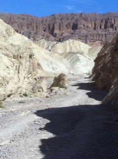
I kept the watch on the altimeter function for most of my time in the Park. I enjoyed observing the readings from time to time and watching them alternate between above sea level and below.  Finally, I arrived at Badwater Basin, my objective, as shown in the photo at the beginning of the post. 

My Pathfinder altimeter reading at this spot was -150 meters; as I mentioned, the watch has recorded this as the lowest altitude I've taken a reading at so far.  Adjusting for the -45 meters margin of error, we get -105 meters, or roughly -326 feet.  The reading was about 44 feet off, indicating that I was further below sea level than the actual elevation, and the margin of effor was off by around 15%. 

That is usually good enough for me - I mainly use the altimeter to give myself an idea of my progress on a climb or descent while hiking.  I don't expect or require precision on these readings, just need an idea of how much elevation is left to the particular effort I'm involved in.  There are other instruments to use if better precision is needed.

(I should mention that the mountains that surround Death Valley are quite high - to the west, they reach to just more than 11,000 feet above sea level.)

So, for the record, the established high and low points for my watch are:

High Point:  Glacier Point, Yosemite National Park, 2,315 meters (approximately 7,177 feet) recorded July 20, 2010.
Low Point: Badwater Basin, Death Valley National Park, -150 meters (adjusted for errors, 105 meters; translating to -326 feet), recorded October 12, 2011.

These are nominal readings, as I discussed above.  And between the highs and lows, we have all those readings in my beloved stomping grounds back at Shenandoah National Park.

Thursday, October 13, 2011

Las Vegas Guilty Pleasures

When I posted about the Bud in a Bag yesterday, I had no idea that I was making one of those “What happens in Vegas stays in Vegas” types of confessions.


There was quite a bit of commentary on my disclosure, some of it simply sarcastic, as in this case:

“Classy!!” wrote Chris, and later Mary.

Then there is the discussion from my friend Brian, who is my mentor on the use of the Glen Bacon Scale (GBS), which I used to rate the Bud in a Bag experience – and I was pretty generous, giving a rating of 8 off a 10-scale system.

Brian said, “I don't know where to begin to tell you how wrong it is to rate stupid B*dweiser an 8 on the GBS!!! It's not even a real Beer! It's made with rice, #fercryinoutloud! That's Sake in my book, not Beer!!! You have lost your GBS privileges! Glen Bacon's lawyers will be contacting you in the morning!!!”

I am still waiting for the attorneys to call, but in the meantime, we had a couple of follow-up conversations on the topic. I mentioned how I was impressed by the presentation and how the beer accompanied the Hash House’s “farm food with at twist” cuisine. Then we went into some discussion about the subjective nature of the GBS, ending up with thoughts of how a Cuban judge might have rated the experience in a way that was dissonant with the rest of a given panel.

To which Brian responded, “Fine! Give 4.9 points for presentation and zero for that swill that pretends to be Beer! Even if the Beer had been a Guinness® wrapped in a silk kimono, the 8.0 GBS is very hard to give out willy-nilly. I really doubt a Cuban Judge would be stupid enough to order a B*dweiser.”

Okay, so here we are the morning after, and in light of the clarifying lesson I am ready to reconsider my GBS for the Bud in a Bag. I’m giving it a 6.5. That’s 4.9 for presentation, .5 for size (22 oz.), .5 for icy cold temperature (we’re out here in a desert, for kriminees sake), and .6 for price ($4.95 – that’s like 1988 prices!).

But you know, the comment that hurt the most came from neighbor Dan, the homebrewer who also grows his own organic hops, as reported in my posts with the Beaver Run Brewery label.

Dan said, “I can't believe you'd admit to that one!”

He also offered some further clarifications and a sort of consolation. “Just bottled 58 pints of FlatTail IPA this past week. Used 8 ounces of homegrown Cascade for the finish. Better hurry back to the pines for a tasting. It should be acceptable to serve the week of October 24th.”

So I’ve got that going for me. In the meantime, since my departure isn’t until 7pm this evening, I think I am going to mosey on over to the Strip and have lunch at the Hash House again. All this talk about Bud in a Bag is making me thirsty.

Wednesday, October 12, 2011

Las Vegas Eats (and Drinks)

Let's get this straight from the beginning.  I am not here for the gourmet treatment.  This is a road trip where I luckily can mix business with pleasure. On a 30/70 ratio.

This photo is from Hash House a Go Go, linked at the end of the post.  It wasn't long afterwards that the entree followed up, a big ol' grilled ham and cheese with a slice of tomato and house romaine salad on the side.  And I was out of there for $18, including the beer and tip!

I'd found a couple of reviews about the place that settled me on this choice...keywords "locals" and "farm-fresh."

First, from the "Las Vegas" mag in the hotel room-

A locals hot spot, the eatery is known for its oversize portions of creative breakfast, lunch and dinner dishes like the HH famous roasted chicken pot pie and crispy Indiana-style hand-hammered pork tenderloin.

And from another hotel rag "Where"-

Hearty portions of award-winning, farm-fresh food that are comforting day or night.

I guess it has shown up in a few travel shows by now.  Hearty is an understatement, that's why I tried to tone it down with the grilled cheese and salad.  But who knew it would show up on Texas toast?

For lunch yesterday, one of the folks from the trade show organizer sat down next to me in the speaker ready room with a plate of BBQ.  Turns out, there was a B.B. King restaurant in the Mirage, and I wouldn't have to walk through the casino to get to it.  So after I concluded my business with my little talk, and then a walk around the exhibition, I headed off to lunch.

These days I worry about diet when I'm traveling.  Well, perhaps worry conveys the wrong impression.  Revised, that should be, "These days, I consider my diet when I am traveling."  Restaurant food is usually pretty good, but it is rich and often as not loaded with cheap calories from ingredients you don't know about.

But I can often rationalize these things, as I did yesterday, when I recalled that the walk from my hotel up the strip to the Mirage was just about 3 miles, per my GPS.

And so I thought about that a moment in B.B. King's, while I read about the pulled pork and the brisket.  I settled on a blackened mahi sandwich, proud of making the fish choice.  It came with fries AND cole slaw. And a Flat Tire pint. My table had a tribute to Elvis. 

"Bright lights city gonna set my soul on fire." Not to mention the potential for heartburn.

Final one, only because of the siren call of the neon sign across the street from the hotel.  And because of its prominence in that one scene in The Big Lebowski.  We've got your In-n-Out right over there...when I was in Barstow last May I made a stop, and since I can walk to this one...well, let's just say I knew what's for dinner on the first night.

For my friend Brian, I'll do the Glen Bacon scale for the Hash House meal:

Bud in a Bag:  8 6.5 - this unique treatment for a beer that is an ideal refreshment in this heat with all the walking probably could get a higher rating, but I don't want to inflate these things.  Seriously, I'd had a Flat Tire earlier in the day already!

***Editor's Note.  I need to explain the revised rating above, which is reported extensively in the next day's post.  As discussed there: "Okay, so here we are the morning after, and in light of the clarifying lesson I am ready to reconsider my GBS for the Bud in a Bag. I’m giving it a 6.5. That’s 4.9 for presentation, .5 for size (22 oz.), .5 for icy cold temperature (we’re out here in a desert, for kriminees sake), and .6 for price ($4.95 – that’s like 1988 prices!). Now back to the original post...

Grilled Ham and Cheese:  7 - I liked it.  But on Texas toast, it was kinda big and over the top.

Here's the link to Hash House - turns out its a growing chain:  http://www.hashhouseagogo.com/